| |
|
May 10, 2013 6:46 PM
Posted By Robin & Jim
|
We arrived in Blaine, Washington on the US/Canda border on Monday afternoon, and we have been continuing to track the EUROGRACHT's progress up the coast. She's due into Victoria, BC tomorrow (the 11th) and we're scheduled to be offloaded first on Sunday morning. We can't wait!!!
To backtrack a bit... after our adventures in Idaho we headed across the north end of Oregon to visit Robin's cousin Mike and his family in Hood River. We traversed some big green mountains, crossed through more farmland, and then descended into the Columbia River gorge - wow! We never realized how beautiful and dramatic the gorge is, and how wide the river runs so far from the sea. There are a number of locks and dams and hydro power stations along the river's course, and we saw tugs pushing large barges.
The town of Hood River reminded us of some of the Maine coastal towns - picturesque, perched on a hill above the water with interesting shops and cafes. The tall evergreen trees on the hillsides give way to orchards of apples and pears as the road turns south away from the river gorge. What a gorgeous area! There are clear views of the snow-covered Mt. Adams to the north, and Mt. Hood to the south.

Robin's cousin lives on a big piece of property with evergreen trees, wild blackberries, grouse, a pond full of very vocal frogs, red winged blackbirds, and a few pairs of pheasants. The male pheasants seemed to respond to a neighbor's roosters, and they put on a show of dancing and singing every morning. It was wonderful to reconnect with family and to share stories from our childhood - we had a lot of laughs!
The area also boasts some stunning waterfalls, with a nice hiking trail that connects many of the falls, culminating in Multnomah Falls. Wonderful!
After a brief stop in downtown Seattle to pick up a few more parts for our heating system, we arrived in Blaine. Actually, we accidentally went to Canada. Briefly.
We were trying to find a grocery store so we could pick up some things for the friends we are visiting with. Jim searched for "grocery store" in the car's GPS, and found a nice store 2 miles away... except that he didn't notice the store was in Canada. We jumped back on the highway and found ourselves at the Canadian border gates, with no possibility of a U-turn. Good thing we had the passports handy. The border guard was pretty nice about it, and they checked us into Canada and directed us to a U-turn so we could wait in line to go through the US border gates. A little adventure!
We visited with friends we met in Marathon this winter, and waited until today when it was time to head to Victoria to meet our ship, as well as see Jim's dad who happens to be making a port call in Victoria on a cruise ship tomorrow.
It's only just beginning to sink in that we're "here". I think it will feel real when we're back aboard our home on Sunday.
|
|
May 9, 2013 6:46 PM
Posted By Robin & Jim
|
We have really been enjoying our exploration in the west, and we seem to be most drawn to places with unique landscapes. Keeping with that theme, we left Salt Lake and drove up into Idaho to hike in Craters of the Moon National Monument.
The Snake River plain runs across southern Idaho and is mostly flat terrain in an otherwise mountainous state. The 52-mile long Great Rift is a series of deep fissures in the earth which are volcanically active. About 15,000 years ago lava oozed out of the ground (as opposed to erupting from a volcano formation) and created a huge plain of lava that was active as recently as 2000 years ago. The size of this flow is mind-boggling!

The park covers about 750,000 acres and it has examples of a variety of volcanic formations: pahoehoe lava, ah-ah lava, spatter cones, cinder cones, craters, and caves created by lava tubes that have collapsed. Jim is posing near some small spatter cones here, and we hiked to see some larger ones later in the day.

Next we hiked up a steep cinder cone that was composed of soft, crunchy dark gray cinders with no other color or vegetation. When we got tot he top we found some red rocks, small shrubs, a single tree, and a fantastic vista across miles and miles of lava plain.

We hiked the trail around Broken Top cone, scrambling down the rocks to explore Buffalo Cave. Despite relatively warm temperatures, the cave was quite cold and icicles were hanging from the ceiling. Continuing on we saw such a varying landscape with different kinds of lava flows, "bombs" (blobs of rock ejected from an eruption), cinders, and the occasional pretty flowers, trees, and shrubs.

Despite its inhospitable appearance, Craters is home to a variety of wildlife. We saw some little pika - similar to a chipmunk but without a tail, and antelope in the territory just outside the park. We saw evidence of lava all across southern Idaho, in the farmer's fields as well as the pastureland.

We had a great day and really enjoyed the contrasting kind of beautiful scenery. We've been lucky with this trip and we've loved seeing and learning about new things. This land is pretty amazing, and we're just barely scratching the surface.
|
|
May 9, 2013 11:49 AM
Posted By Robin & Jim
|
There are a number of National Parks in southern Utah, which is a testament to the amazing formations and shapes that can be found across the state: Arches, Canyonlands (with three different entrances and major districts), Bryce Canyon with its colorful "hoodoos", and Zion with its towering cliffs. Bryce and Zion are part of the "Grand Staircase" which continues down to the Grand Canyon in Arizona. It is an amazing and magical region well worth extended exploration.
Nearly across the road from Arches National Park with its red rock fins and arch formations is the entrance to Canyonlands National Park's "Island in the Sky" district - a land of pinnacles and buttes cut by the Colorado River. We didn't have time to venture into Canyonlands, but we were able to stop at the oddly-named Dead Horse Point State Park near Moab, which offers a stunning vista 2000' above Canyonlands and the Colorado River. This view looks more southeastward with the snowcapped La Sal mountains in the distance.

And this is our favorite view over a horseshoe bend in the Colorado, with miles of dramatic territory begging to be explored. We are standing at about 6000' above sea level to get this view, but remember it all used to be an inland sea about 300 million years ago!

You may notice that there isn't a lot of vegetation (an understatement!), because this is the high desert and this area averages about 10" of rain per year. But the plant life that does exist is hardy and adaptable to live in this environment. And it is also beautiful, like this indian paintbrush flower.

Between Colorado and southern Utah we've had some great animal sightings - mule deer, elk, buffalo, cottontail rabbit, chipmunks, lizards, as well as a lot of hawks, including peregrine falcons, kestrels, and harriers.
After savoring the dramatic view we had to keep making miles and head into Salt Lake City to visit friends. We lived in Salt Lake for 2 years in the early 90's to go to grad school at the University of Utah, and we really loved the area and the people there.
The beautiful Wasatch Mountains still had a healthy layer of snow, though the ski areas closed recently. The hard-core people were still hiking up to enjoy a few runs though.
We had to drive up the canyon and visit our old favorite ski area - Brighton, and Jim was a good sport about posing on the snow. And yes, I did throw a snowball at him!

On the way back down the canyon we saw a coyote in the woods - pretty cool! We had a marvelous time catching up with our friends, and seeing the Olympic cauldron and all the growth in the area.

|
|
May 8, 2013 8:24 PM
Posted By Robin & Jim
|
300 Million years ago part of the western US was an inland sea, covered in salt water. We can remember hiking in parts of southern Utah where the ground is littered with small shells as far as the eye can see. The salt left behind when that inland sea evaporated created salt domes that were eventually covered by dirt and debris from wind and floods, cementing into a cap of rock over the ages. Between the unstable salt domes and geologic faults, the land collapsed in places and was uplifted in others. Further shaping was done by water and wind, eroding the sandstone rock into freestanding fins, and some of those fins developed arches and windows. That is the story of the amazing shapes in Arches National Park in Utah - one of our favorite Parks.

Arches is interesting because of the unusual shapes as well as the red color of the Entrada sandstone, on top of the tan Navajo sandstone. We didn't have the time to photograph Arches at its finest - when the sun gets low in the sky the warm late-day light makes the red rock look even more red... and then the red rock reflects light onto other red rock between the fins and the result is a deep flaming effect that is truly stunning. We used to live in Utah and we have seen the beautiful color of the rock many times in the past.
We hiked up to our favorite arch - the iconic Delicate Arch, which is a long, steep hike across the slickrock.

Arches has become much more popular in the last 20 years, and we had to hike up early even on a weekday to avoid too many people. It's always well worth the climb and we saw a desert cottontail rabbit and a pretty yellow and green collard lizard on the way.

Landscape Arch is another famous feature, located in the Devil's Garden area, and it is the largest with a span of about 300'. This is as close as we can get since part of the arch collapsed in the last 20 years and the rock is getting thin in spots.

Another of my favorite spots is Balanced Rock - and the balanced part of the rock is the size of 3 school buses!

We made the most of our day at Arches hiking a lot of miles, and were rewarded with this view of the huge formation called Park Avenue at the end of a great day.

The next stop on our road trip was Dead Horse Point State Park on our way up to Salt Lake City - another place with lots of memories.
|
|
May 7, 2013 7:03 PM
Posted By Robin & Jim
|
As our roadtrip across country continues, we headed from New Mexico into southwestern Colorado to visit Mesa Verde National Park. Jim had never been there before, and I was there once with my brother and parents about 27 years ago - with lots of happy memories.

Mesa Verde is a vast (81 square mile) wide plateau that sits high above the low desert, rising to about 8400' in height. Between 600-1300 A.D. the ancestral Pueblo (sometimes known as the Anasazi) lived and farmed on the mesa and in its valleys, eventually building dwellings in natural alcoves in the cliff faces.

Cliff Palace, shown above, is the largest group of dwellings in the park, and is amazingly well preserved despite time and weather. There are many alcove buildings around the park - some small and ceremonial, some larger.

The reason these people moved on sometime after the year 1300 remains a mystery, though a long drought and difficulty maintaining a strong corn crop is suggested as the likely reason. It is thought that these Pueblo people are now part of the Hopi and Zuni (as well as other) tribes in the southwest.
We really enjoyed hiking around the park and seeing the amazing structures built into the cliffs, trying to imagine what life was like for these people. They must have been part mountain goat, since we had to do a lot of climbing to see the dwellings up close!

We're enjoying everything about the trip so far - exploring, seeing new and familiar places, learning new things, hiking, and watching the endless changes to the shape and color of the land.
From Mesa Verde we headed into southern Utah's famous Red Rock country near Moab. We had been there several times before about 20 years ago, but had never driven there from the southeast. It was amazing watching the land transform from the mesa and forest to the yellow and red desert with weird shapes.

We are headed to one of our favorite places - Arches National Park, full of bizarre rock shapes and strong red color for more hiking and exploring (and photography, of course!)
|
|
May 4, 2013 12:39 PM
Posted By Robin & Jim
|
We are thoroughly enjoying our adventures as we drive across the country. We've been making good progress and we're actually in Twin Falls, Idaho this morning, but it will take several entries to catch up on some of the wonderful places that we've stopped to explore along the way. As of this morning, the Eurogracht is off the Baja Peninsula, making her way to Ensenada, Mexico.
After enjoying a day of art museums and galleries around Santa Fe, we headed to the badlands of New Mexico to hike in the Bisti Wilderness - a Bureau of Land Management area. It is not widely known and has few visitors, but we fell in love with the strange colors and utterly surreal landscapes, changing at every turn.

There are no trails in the area so you just hike along the vast wash and venture up into the hills and shapes around the edges. You have to be careful not to get lost if you get into the hills too far, though a high point would give you enough vantage to see where the dirt road is.
Some of the mysterious feeling comes from these areas of rocks that look like they were tossed here by some giant hand, though their color is completely different than the surrounding land.

And then we came upon my favorite spot - the "cracked eggs" which look like something out of a science fiction movie.

And then in the nearby hills the colors turn green and black and yellow, with hills of brick red just next door. We also found a lot of petrified wood, but only in certain areas. We would have given anything to have a geologist along with us to explain some of this amazing place!

If you wanted to shoot a science fiction movie, this would be the perfect place. The scenery was just impossible to believe - the shapes and colors, and combined with the quiet it was an eerie place. I could spend weeks exploring and discovering what's behind the next hill.
Unfortunately we had to move on down the road, but we decided to swing past the Navajo Nation's sacred Shiprock to take some photographs. Shiprock is HUGE, jutting out from the flat plains and dominating the landscape of mesas, buttes, and valleys in the area. We could see it from quite a distance, but we ventured closer to take advantage of the sun getting low in the sky. There is a great rock rift that runs south from Shiprock, and that's what you see in the foreground. Stunning, and well worth the detour to see it up close.

From New Mexico we headed into Colorado to visit Mesa Verde National Park - another amazing place.
|
|
April 26, 2013 7:59 PM
Posted By Robin & Jim
|
We're temporarily homeless while ADVENTURES makes her way up the Pacific coast, but we're trying to make good use of the chance to see some new as well as familiar places as we drive across the US.
After spending time with friends in Fort Lauderdale, Palm Beach, and Jupiter our next stop was Clearwater, Florida to see Jim's dad and some other friends. What better way to bid farewell to sunny Florida than to zip around on Segways through Fort DeSoto Park? We saw lots of birds and enjoyed a picnic lunch by the beach. Remind me again why we're leaving the balmy breezes and palm trees and our friends behind?

We have been enjoying the driving - surprised at the pretty forested mountains through western Georgia and into Alabama, then through Mississippi and into Memphis for a short afternoon break.

We took the tram over to Mud Island to see the 1/2 mile long Riverwalk - a living model of the lower Mississippi River. Did you know that more than 1/3 of the US rivers drain into the Mississippi?

We loved reading about all the history of the region and the ever-changing shape of the River, sometimes swallowing towns and sometimes stranding them inland. I don't think we appreciated the Mighty Mississippi as much as we should, but we're glad we learned a little bit more in our brief visit. No trip to Memphis would be complete without enjoying the ribs at the Rendezvous Restaurant - thanks to our native Memphis friends for steering us to the best BBQ!
We continued to zoom through more states, and I regret not having the time to stop and photograph some of the unusual sights along the way, such as the sign advertising the town of "Toad Suck, Arkansas". You can't make this stuff up. We made miles through Oklahoma and Texas across Route 40, and arrived in Santa Fe to take a day off to play. The high desert is so stark and beautiful - a real contrast to the verdant scenery we had just a few days ago. Santa Fe is full of art galleries and art museums, and we enjoyed seeing the work of Georgia O'Keefe as well as other local artists and photographers. The sky is a brilliant blue which really sets off the adobe construction and desert flora - so beautiful.

Our next adventures will be hiking and exploring some of the unusual landscapes and history in the Four Corners area of the southwest. But our thoughts are still with our boat aboard the EUROGRACHT, making her port call in Golfito, Costa Rica this morning.
|
|
April 24, 2013 11:19 AM
Posted By Robin & Jim
|
One day we hope to transit the Panama Canal on our own bottom, but in the meantime it's still very cool to see ADVENTURES make the trip one way or another. As we're driving across country we've been watching for the EUROGRACHT (our ship) on marinetraffic.com. Here is one more photo of our boat being loaded on the 450' EUROGRACHT a week ago in sunny Palm Beach, FL - she looks so tiny.

The EUROGRACHT popped into range on marinetraffic.com as she approached the Panama Canal yesterday morning, and we kept checking to see when she entered the Canal so we could catch a glimpse of ADVENTURES on the Panama Canal's web cams. It looked like the ship anchored to wait for the Pilot, and we couldn't tell how long the wait would be. The ship's position didn't update for many hours, until we finally saw her transiting Gatun Lake (in the middle of the Canal) late last night. We missed seeing her on the Atlantic-side (Gatun) web cam in daylight, but we stayed up very late to watch her come through the Pacific-side locks at Miraflores. It was dark and the Canal's lights made a harsh glare on the web cam, but we could clearly see the EUROGRACHT entering the first of the two Miraflores locks, with a big load of boats on her deck.

ADVENTURES is all the way towards the back of the ship's superstructure, in the center. We could barely make her out in some of the web cam shots, but it was still a big thrill to see her one more time before we get to Victoria. She has made this trip through the Canal once before, aboard a ship, when she was first delivered to Florida after her construction in Taiwan back in 1988.
As the EUROGRACHT was exiting the lock we caught a better (but still pretty bad) view of her, as well as the Outer Reef GINGER owned by a friend.

It was about 2:50 in the morning east coast time when the EUROGRACHT cruised out of the locks and into the Pacific Ocean, and now we just have to watch for when she makes port calls in Golfito, Costa Rica and Ensenada, Mexico before we'll see her in Victoria.
It's hard to wait!
|
|
April 20, 2013 3:20 PM
Posted By Robin & Jim
|
There are many stories and photos from this winter season in Marathon that we want to catch up on, but that will be the topic for later blog entries.
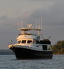
The big news to report is that ADVENTURES has been safely loaded aboard the 450' Dutch freighter EUROGRACHT in the Port of Palm Beach for her journey through the Panama Canal and up to Victoria, BC, Canada. This is the ship approaching Lake Worth inlet.
She's due to arrive in Victoria around May 9th and we're driving across country to meet her and to begin some years of cruising in the beautiful Pacific Northwest.
Preparing our only home for a big ocean journey is a daunting task - we worked for about a week to get everything lashed down, stowed, secured, and ready.
On Wednesday afternoon we drove ADVENTURES to the side of the EUROGRACHT and watched the loadmasters bring lots of heavy straps aboard and then position the wide lifting straps from one of the ship's cranes.


Divers were in the water to help position the huge lifting straps under the hull and make sure they were clear of the stabilizer fins. At the last minute we had to lower 6 antennas so they would clear the overhead lifting bar. Once everything was ready for lifting we boarded a small launch and waited near the ship to watch her get settled on deck.

We've seen our boat hauled out of the water for maintenance periodically, but it's a different feeling watching our home lifted high out of the water an onto the deck of a ship!

On Thursday we were allowed back into the Port and aboard the ship so we could put the antennas back up - the loadmaster told us the antennas would ride better upright. It was very interesting to get aboard and see the deck full of more boats, and the welded cradles and stands, and all the straps holding boats to the deck. The crew had still not finished installing the spiderweb of straps, but it's a pretty impressive operation.

The EUROGRACHT finally departed around midnight on Thursday, heading for the Panama Canal. We have a long drive ahead of us, and we'll use that time to catch up on the blog from our busy winter. We'll also be watching the weather to see what the EUROGRACHT and ADVENTURES are experiencing. Victoria, here we come!
|
|
January 11, 2013 11:10 AM
Posted By Robin & Jim
|
We had a great cruise into our beloved Florida Keys. We anchored behind Pumpkin Key next to the very exclusive Ocean Reef Club at the north end of Key Largo so we could jump out to the ocean side of the Keys for the rest of the trip to Marathon. The path to Hawk Channel is through Angelfish Creek which has notoriously shifting shoals at the mouth. We had to transit it at the top of high tide, and our reward was a beautiful Keys sunrise as we got to the ocean.

We had a nice cruise down Hawk Channel, though it's important to keep a sharp watch out for crab pots! The floats they use here in the Keys are pretty small and they can be hard to see until they are close. Hawk Channel is fairly shallow - 15-25' on average. It runs on the inside of the reef so it has better protection from ocean waves; on the outside of the reef the depths drop off dramatically and the Gulf Stream current often comes very close to the edge.
The Keys are about 100 miles long - a chain of islands connected by bridges first built by Henry Flagler for his Overseas Railroad in the early 1900's. You can see the tractor trailer on this bridge...
No trip to Marathon would be complete without a storm. We ALWAYS seem to get a little storm just to make things interesting. This year it was only a series of smaller rain squalls, but they passed very near us and made it a little exciting. As we approached Sombrero light we could see the closest dark clouds and rain.

We dodged the weather and tucked into our usual slip well before sunset. We have the nicest view of the sun setting into the ocean right from our slip, and sometimes we get lucky enough to see a green flash (if the conditions are right).
Early December is the usual time for the various holiday boat parades, and we enjoyed the small but enthusiastic parade that passed right by our marina.


We got into the spirit of it all and Jim outlined ADVENTURES in lights, and I put up a lot of our little decorations.
We've had a bit of excitement around here - some Cuban refugees made landfall by climbing on a neighbor's boat and then scrambling up onto the dock. A good friend had a bad fall off the dock and broke his leg. And the marina's general mgr. was arrested for drug smuggling and attempted murder-for-hire. There's always something interesting going on around here!
|
|
|